9842105-6, Ext:142

Forecasting & Warning Message
Forecasting & Warning Message

The terms and definitions found in the glossary relate to Flood Forecasting and Warning.
flood occurs when water inundates (covers) land which is normally dry.
The floods in Bangladesh are divided into monsoon river flood, flash flood, local rainfall flood and storm surge flood. Monsoon river flood is an annual event forced mainly by intensive river inflow through Ganges, Brahmaputra and Meghna Rivers and rainfall over Bangladesh as causes the water level in the rivers to rise and fall slowly during the monsoon season. Flash flood occurs only in the northeastern Bangladesh in the period pre- to post-monsoon forced by intense rainfall in the Meghalaya Hills and in parts of eastern Bangladesh in the post-monsoon. Local rainfall flood is, as the name states, forced by local heavy rainfall over a location inside Bangladesh. Storm surge flood is a coastal phenomenon forced by cyclones hitting the Bangladeshi coastline.
Flood of short duration with a relatively high peak discharge.
Estimation of height, discharge, time of occurrence, and duration of a flood, especially of peak discharge, at a specified point on a stream, resulting from precipitation and/or snowmelt.
Advance notice that a flood may occur in the near future at a certain location or in a certain river basin.
In Bangladesh danger level at a river location is the level above which it is likely that the flood may cause damages to nearby crops and homesteads. In a river having no embankment, danger level is about annual average flood level. In an embanked river, danger level is fixed slightly below design flood level of the embankment. The danger level at a given location needs continuous verification as e.g. embankments may be breached, but it is not done continuously by FFWC, whereby some danger levels may be not precise.
BWDB and other government departments refer water levels to the Public Works Datum (PWD). PWD is a horizontal datum believed originally to have zero at a determined Mean Sea Level (MSL) at Calcutta. PWD is located approx. 1.5 ft below the MSL established in India under the British Rule and brought to Bangladesh during the Great Trigonometric Survey.
Any or all of the forms of water, whether liquid (e.g. rain, drizzle) or solid (e.g. hail, snow), that fall from a cloud or group of clouds and reach the ground.
In contrast to showers, rain is steadier and normally falls from stratiform (layer) cloud. Liquid water drops greater than 0.5 mm in diameter. Rain can range in intensity from light to very heavy.
Usually begin and end suddenly. Relatively short-lived, but may last half an hour. Fall from cumulus clouds, often separated by blue sky. Showers may fall in patches rather than across the whole forecast area. Range in intensity from light to very heavy.
Fairly uniform precipitation composed exclusively of very small water droplets (less than 0.5 mm in diameter) very close to one another.
Thunderstorms are one or more convective clouds in which electrical discharge can be seen as lightning and heard as thunder by a person on the earth's surface. A severe thunderstorm produces one or more of :-
Water available, or capable of being made available, for use in sufficient quantity and quality at a location and over a period of time appropriate for an identifiable demand.
Determination of the sources, extent, dependability and quality of water resources for their utilisation and control.
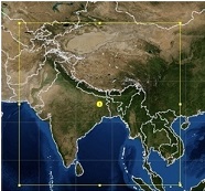
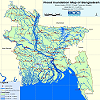
A river's catchment (or basin) is the land area from which rainfall will ultimately contribute to the river discharge. The catchment area of the Ganges, Brahmaputra and Meghna Rivers are 907 X 103 km2, 583 X 103 km2 and 65 X 103 km2, respectively, of which only 8% lies in Bangladesh. More than 90% of the water that flows into the Bay of Bengal enters Bangladesh through its borders with India.
FFWC simulates the water level conditions in Bangladesh by use of a numerical model of the Bangladeshi river network. The model is named the "Super Model" and is based on measurements of the topography of Bangladesh and the general numerical hydrodynamic model system named MIKE 11 developed at DHI Water & Environment. To run the Super Model information on water level and rainfall is needed to force the model: water level boundaries are e.g. found upstream in Ganges and Brahmaputra and downstream in Meghna River. The Super Model has been run at the FFWC since 1998.
Water is the lifeblood of the weather. It moves into the atmosphere as water vapour through evaporation from water surfaces or through transpiration from plants. The vapour condenses in the atmosphere to form clouds and returns to the surface as precipitation (rain, snow or hail) and in small quantities as fog, dew or frost. Water falling on land is destined for one of many fates. If it falls as snow it can spend some time in a snow or ice-field before moving off as a glacier and perhaps eventually becoming part of an iceberg. Or it might melt and join a river. If it falls as liquid drops it might be retained in the soil as moisture for plants, or it might join a river, or be stored for a time in a lake or reservoir. Ultimately rain or snow falling over land will either find its way back to the ocean or be evaporated back into the atmosphere, from where it will move along through various branches of the eternal water (hydrologic) cycle.
The atmospheric conditions for a long period of time, and generally refers to the normal or mean course of the weather. Includes the future expectation of long term weather, in the order of weeks, months or years ahead.
Bangladesh is characterized by a tropical climate, i.e. 'cool', dry winter from November to January with predominantly northeasterly monsoon winds; hot, humid summer from April into October; and wet monsoon from June to September with predominantly southwesterly monsoon winds. Flooding in Bangladesh occurs during the wet monsoon period.
The green house effect is a change in the global climate due to mans activities. The IPCC "Business-as-Usual emissions scenario" predicted water level rise forced by green house effect is about 20 cm in global mean sea level by 2030, and 65 cm by the end of next century. There will be significant regional variations. Also the climate of Bangladesh may get warmer and wetter. The monsoon rainfall is estimated to increase 10-15% by the year 2030. Little is known on changes in cyclone frequency and intensity. Presently FFWC does not investigate the consequences of the green house effect.
An El Niño/Southern Oscilation (ENSO) episode is a disruption of the ocean-atmosphere system in the tropical Pacific having important consequences for the weather and climate around the globe. Abnormally warm waters in the equatorial central and eastern Pacific characterize an ENSO episode. During ENSO episodes abnormally dry conditions over northern Australia, Indonesia and the Philippines are found, and the Indian monsoon rainfall tends to be less than normal. It is possible that ENSO episodes influence flood conditions in Bangladesh and research project are investigating the connection.
Bangladesh is one of the most flood prone countries in the world. Due to its location in the low-lying deltaic floodplains at the convergence of three Himalayan Rivers: Ganges, Brahmaputra and Meghna (GBM), heavy monsoon rainfall concomitant with poor drainage often results in annual flooding. These river systems drain a catchment area of about 1.662 million sq. km. The floodplains of the rivers are home to a large population, most of which is rural and poor, and whose life is intricately linked to the flooding regime. Recurrent floods cause widespread damage in rural and urban areas and set back the country's efforts to alleviate poverty. Huge cross-border inflows, low-line topography, deposition of sediment in the rivers, infrastructure development in floodplains have made the country highly vulnerable to flood. As a deltaic land, the ecosystem of the country is water based, and flood is a part of life of the country�s environment. No disagreement that recurrent high floods damage the economy and causes tremendous sufferings to the lives. The reality is that flood brings sufferings to lives for very short time but absence of flood will cause sufferings for much longer. The country needs floods along with the flood coping strategies and flood management provision to reduce damages and sufferings. Flood forecasting is a very effective flood management activity that is being extensively applied in all over the world. In Bangladesh, flood forecasting was started in 1972 through establishment of Flood Forecasting and Warning Centre (FFWC) under the Bangladesh Water Development Board (BWDB). Institute of Water Modelling (IWM) frequently provides technical support to FFWC for smooth operation and updating of the Flood Forecasting and Warning System. This site describes upon the updates of our endeavor on research in the field of quantitative flood forecasting and warning services.
The prime objective of this research is to devise a high performance flood forecasting system with least expenses of resources and at the earliest of the day. The specific objectives are:
This flood forecasting system is completely numerical model based. Uses several models: Weather Research and Forecast (WRF) model, hydrological model (MIKE 11 NAM & MIKEBASIN of Danish Hydraulic Institute), and hydrodynamic model (MIKE 11 HD of Danish Hydraulic Institute). Now cast is generated using real time precipitation data where as forecast is generated using precipitation prediction.
Under the system, cross boundary inflows into the country are predicted through simulation of the GBM model. The GBM basin model is simulated for 1 year hindcast and 6 days forecast period using real time rainfall and predicted rainfall, respectively. Using the predicted cross border inflows and predicted rainfall, the Flood Forecasting Super Model is simulated within the country for generating flood forecast with lead time of 5 days at 54 stations of major rivers.
Weather Research and Forecasting(WRF) model has been customized for the domain extending 406?28.8?? to 46037?4.8?? Latitudes and 65013?50??to 107041?45.6?? Longitudes encompassing theGBM basin. The model is simulated once in every day at IWM for generating weather forecast with lead time of 6 days. The (WRF) model is a next-generation mesoscale numerical weather prediction system designed to serve both atmospheric research and operational forecasting needs. The WRF is effort of a collaborative partnership principally among the National Center for Atmospheric Research (NCAR), the National Oceanic and Atmospheric Administration (represented by the National Centers for Environmental Prediction (NCEP) and the (then) Forecast Systems Laboratory (FSL)), the Air Force Weather Agency (AFWA), the Naval Research Laboratory, the University of Oklahoma, and the Federal Aviation Administration (FAA).
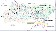
The Ganges Brahmaputra Meghna (GBM) river basin model is developed using MIKE BASIN, the GIS based water resource modelling interface of DHI Water & Environment, Denmark. The model is developed at Flood Management Division of IWM in 2007 based on land terrain data of SRTM, and meteorological data (rainfall, temperature and evaporation) obtained from public domain. Areal extent of the GBM model is around 1,526,733 sq.km: Ganges 979,503 sq. km, Brahmaputra 520,663 sq. km. and Barak (Meghna) 26,567 sq. km.The GBM basin model is tested for hydrological events of 2010-2013. The comparison plots of simulated and observed discharges at the outlets of basins of the Ganges (at Hardinge Bridge), Brahmaputra (at Bahadurabad), Barak (at Amalshid), Teesta (at Dalia), Dudkumar (Nageswari), and Dhara (Mogol basha) rivers are shown in following figures.
The contents of this website are products of Research and Development activities of Institute of Water Modelling (IWM). The information herein are for sole and specific use of the Institute....
 Rain Map
 Rain Map
 Flood Map
Bulletin df
Sattelite Rain
Flood Map
Bulletin df
Sattelite Rain
Designed By : ![]() Md. Shahadat Hossain
Md. Shahadat Hossain